GUIDANCE
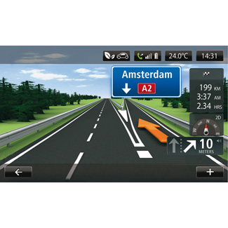
Lane images
When approaching a road change (on major roads), the system may switch to “Show lane images” mode: an 3D image provides a close-up view of the junction with a turn arrow and road signs.
To deactivate lane images, please refer to the information on “Advanced Settings” in the section on “Navigation settings”.
Guidance screens
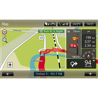
Intersection map
During guidance, before each change of direction, the system will gradually zoom into the junction.
To deactivate automatic zoom, please refer to “Advanced” in the “Navigation settings” section.
Guidance Voice
During guidance, before each turning, the system will give voice instructions.
To deactivate or reactivate voice guidance, please refer to the “Navigation settings” section.
Precautions regarding navigation
Use of the navigation system does not in any way replace the responsibility or vigilance of the driver when driving the vehicle.
Route details
This function allows you to view your route before guidance begins. Press the “+” button, then "Route details” after entering a destination.
The following choices will be available:
- “Display instructions”;
- “Display route map”;
- “Display route demo”;
- “Route summary”;
- “Display destination”;
- “Display traffic on route”.
| “Display instructions” |
This function makes it possible to view the route plan. Several details of the route will appear: - direction-change arrow; - road types; - road names; - miles/kilometres before a fork in the road. | |
| “Display route map” |
This function makes it possible to view the map of the route. | |
| “Display route demo” |
This function makes it possible to view a demonstration of the route. | |


| “Route summary” |
This function is used to return to the previous screen. The details of the journey time, the miles and the type of journey (“IQ Routes™" activated/deactivated) are displayed. Note: to directly access this page from the navigation map, press the information block set for your trip. | |
| “Display destination” |
This function lets you see changes in direction as an image. | |
| “Display traffic on route” |
This function gives you an overview of all the traffic incidents affecting your journey. | |


| Change route |
To modify your route, from the “Navigation” menu, select “Change route” then one of the options proposed. The system calculates the route taking the detour into account. Note: you can add several waypoints to your route. | |

| “Calculate alternative” |
Select this menu to make the system stop the current guidance. To start guidance again, select “Drive to...”, then “Recent destinations”. | |
| “Cancel route” |
Select this menu to make the system stop the current guidance. To start guidance again, select “Drive to...”, then “Recent destinations”. | |


| “Travel via” |
Select this menu to change your route so that it passes by a particular location, to pick someone up on the way, for example. You choose the location you want to pass in the same way as you choose a destination. You have the same set of options: “Locations”, “Saved locations”, “Point of interest” and “Point on map”. Your system will calculate a new route to your destination that passes the location you chose. | |

Precautions regarding navigation
Use of the navigation system does not in any way replace the responsibility or vigilance of the driver when driving the vehicle.
| “Avoid roadblock” |
Select this menu if you see a roadblock or a line of traffic ahead which was not indicated by the “Traffic info” service. You then have to choose how much of the route ahead you want to avoid. Choose among these different options: “100 metres”, “500 metres”, “2,000 metres”, “5,000 metres”. Your system will recalculate your route avoiding the section of the route for the distance you selected. | |

| “Avoid part of route”
|
Select this menu to avoid a part of the route. Use this option if you see that your route includes a road or a junction that you wish to avoid. Then choose the road that you wish to avoid from the list of roads on your route. | |
| “Minimise delays” |
Select this menu for your to plan your route based on the latest traffic information. | |

