TRAFFIC INFORMATION
| “Traffic Information Service” |
Traffic information is a service available on your multimedia system which enables you to receive up-to-date traffic information from the best local sources. The “Traffic” service uses TMC information transmitted over FM wavebands. “TomTom Traffic” uses LIVE services information. These services show events in the form of dots on the map. It covers the main roads and is updated regularly. Note: the menu title can be “Traffic” or “TomTom Traffic". | |

“Traffic Information Service” options
To access the “Traffic Information Service” options, from the main menu press “Services”, “Navigation services”, then “TomTom Traffic".
“Minimise delays”
Select this option to alter your journey based on the latest traffic information.
“Read traffic information”
This menu enables you to activate the audio reading of traffic information.
“View map”
This menu enables you to explore the map and keep up-to-date with the traffic situation in your area. To access the map, from the main menu select “Traffic Information Service”, then “View map”.
The map displays the last searched location. Press the icon for an incident to get more detailed information.
“Traffic settings”
This menu allows you to set the desired default calculation method.
“Display traffic on route”
This menu allows you to see an overview of all traffic incidents on your route. Press the icon for an incident to get more detailed information.
“TomTom Traffic” service
This service is accessible free of charge during a trial period. You can extend your subscription at a later stage. The “TomTom Traffic” service offers more frequent updates (approximately every three minutes), covering main and secondary roads.
Traffic bar
The traffic bar is available for the “Traffic Information Services”.
The side traffic bar displayed in guidance mode, shows the latest traffic information for your route.
Traffic display
The navigation system indicates traffic incidents:
- by displaying symbols on the map (list of icons at the end of the section);
- with voice messages if the route is recalculated.
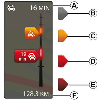
Depending on the operating status of the “Traffic Information Service”, the following icons are displayed on the traffic sidebar:
A Heavy delays on the route.
B Unknown or indeterminate situation.
C Slowdown.
D Traffic jam.
E Stationary traffic or road closed.
F Distance before next incident.
“Traffic preferences”
To access this menu, from the “Traffic Information Services” menu, press “Traffic Settings”.
You can automatically minimise delays after every traffic update.
To select your preference, tick the box to the right of your choice using the central confirmation button.
Once you have made your choice, select “Done”.
Symbol | Meaning | Symbol | Meaning | ||
|---|---|---|---|---|---|
| Accident | | Heavy rain | ||
| Traffic jams | | Snow | ||
| One or more closed roads | | Strong wind, storm | ||
| Road closed | | Fog | ||
| Traffic incident | | Ice | ||
| Road works | ||||
Precautions regarding navigation
Use of the navigation system does not in any way replace the responsibility or vigilance of the driver when driving the vehicle.